Filter the images shown in the lighttable view and filmstrip panel using image attributes. This set of filtered images is known as a collection.
Importing images into Ansel stores information about them (filename, path, Exif data, data from XMP sidecar files etc.) in Ansel’s library database. A collection may be defined by applying filtering rules to these attributes, thus creating a subset of images to display in the lighttable view and the filmstrip module.
Display information embedded within an image’s Exif data as well as a number of additional data fields defined by Ansel.
When hovering with the mouse over image thumbnails, the displayed data is automatically updated to show information about the image currently under the mouse cursor.
When several images are selected and the focus is not on a single image, the module only displays information that is the same for all images.
The filmstrip can be used to quickly switch between images. The images shown are the same as those displayed in the lighttable view and are defined by the currently-selected collection.
The filmstrip can be switched on and off using the shortcut Ctrl+F. The height of the filmstrip panel can be changed by clicking and dragging its top border.
Quickly navigate through the images in the filmstrip by scrolling with the mouse.
Identify which parts of the image contain high-contrast details, like edges and textures, which usually indicates that those areas are in focus.
Activate the module by clicking on the icon. The sharp parts of the image will be highlighted with a yellow, green and blue overlay:
Focus peaking works by filtering out most of the image noise, measuring the intensity gradients in the image and calculating average and standard deviation statistics.
Import and apply GPX track data to a selection of images.
This module is common to the lighttable and map views. The map view provides an enhanced mode that allows you to preview the position of the images along the GPS tracks while adjusting the images’ date/time offset and time zone.
workflow overview A GPS receiver calculates its current position based on information it receives from satellites, and records it in a GPX file together with the current date and time.
Edit the metadata of selected images.
Metadata is freeformat text (title, description, creator, publisher, rights etc.) that describes your images.
When several images are selected having different values for a given metadata field, the module displays for that field – if you choose to apply changes, these fields will not be changed. If you right-click on the field the different values are listed at the end of the contextual menu. Select one of the values in the menu to apply that value to all of the selected images – the change will be saved once you press the “apply” button or the Enter/Tab key.
Display a list of recently used collections generated by the collections module.
This module may be hidden, depending on the collections module preferences.
Click on an entry to reopen the selected collection. This also updates the collections module with the appropriate filter criteria and rules.
preferences The “preferences…” option in the presets menu allows you to adjust the behavior of the recent collections module as follows:
number of recent collections to be stored The number of recent collections to store and display in the recent collections module (default 10) prefer an history button in the collect module Set wether you prefer to use this module or the history button in the collections module.
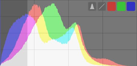
This module provides various graphical depictions of the developed image’s light levels or chromaticity.
Move the mouse over the panel to show buttons that allow you to adjust the display. The leftmost button cycles the mode between histogram, waveform scope, RGB parade scope, and vectorscope. The remaining buttons control how the plot for the current scope is drawn.
When the mouse is over the scopes panel, scroll with the mouse while holding down the Ctrl key to change the height of the panel.
Manage tags attached to images.
Tags provide a means of adding information to images using a keyword dictionary. You can also manage tags as a hierarchical tree, which can be useful when their number becomes large.
Tags are physically stored in XMP sidecar files as well as in Ansel’s library database and can be included in exported images.
definitions The following definitions assume that you have set up a single tag named “places|France|Nord|Lille”.